 This is a revised version of a 2012 blog post. It is more detailed and places the soldiers on Patrick Street instead of Market Street.
I want to share a different view of the historic photograph, Confederate Soldiers in Frederick. The photo shows the soldiers in September 1862 as they march through Frederick, MD, on the way to the battle of Antietam. The original is a beautiful sepia tone print in the archives of HSFC where I am a volunteer. I obtained the black and white electronic copy in this blog courtesy of the HSFC. I heavily sharpened it to show many interesting details. Except for that, I did not alter the content in any way. The enhanced image is drawn, as a “photo overlay”, in a three-dimensional Google Earth map of contemporary Frederick, MD. The overlay allows you to view the scene as the photographer saw it through the lens of his camera.
Using Google Earth
If you want to view the picturex in Google Earth, download the Google Earth (kml) map file and open it in Google Earth. If you don’t have the Google Earth application installed on your computer, get it free at the Google Earth website. When the file opens, you will see the “Confederates in Frederick” link in the Places/Temporary Places panel. Double click on the “Confederates in Frederick” link to display information about the presentation. Click on the “Information” link for important setup instructions and hints about using Google Earth.
If you want to see the results, this blog has pictures, and map image captures that give you a feel for what you see in Google Earth.
Reconstructing the Historic Photo
I will write about how I used clues in the photo to position and align the camera and embed the image in a contemporary three-dimensional Google Earth rendering of Frederick. Later on, I will show some fascinating details from the photo. Before diving into the details, double-click on the “Historic Photo” link to get a preview of the result.
Lee’s Strategy
The next link, “Lee’s Route to Antietam” displays the area included in Lee’s march before the battle. There are many sources of information about the battle including a very informative review of Lee’s strategy in late 1862. 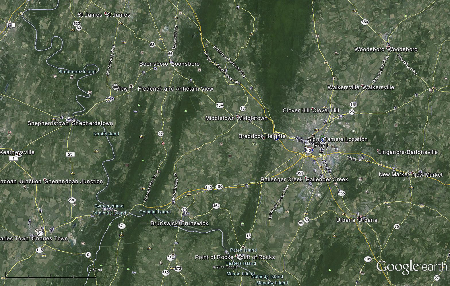 It has an excellent map showing Lee’s Invasion of Maryland and the Union response over the September 3-13, 1862 time period. Frederick was in a strategic location. Lee’s goal was to ” keep the enemy occupied north of the Potomac until the approach of winter would make an enemy advance into Virginia difficult”. After crossing the Potomac near White’s Ford (the “Places” folder at the bottom has a list of Google Earth Placemarks in alphabetical order), the main part of the Army of Northern Virginia reached Frederick by September 7. About 45,000 confederate troops camped in and around Frederick mostly to the south near the Best farm, which later become a focal point of the Battle of Monocacy. On September 10, Lee’s army left Frederick to execute the plan that led to the bloody battles of South Mountain and Antietam. It was probably this day that the photograph was taken.
Location
The sign for Rosenstock’s Dry Goods and Clothing store is in the foreground. The store was at the northeast corner of Market and Patrick Streets. I expected to find the name in the 1859 Frederick Md Directory which I described in an earlier post. Surprisingly, there is no reference to the Rosenstock store or family even though they had been in business since 1855. I am still puzzled by this strange omission. Happily, the Historical Society provided me with the missing information. Two useful references are the “History of Frederick County Maryland, Volume 1” and “The Citizen. Historical and Industrial Edition”, Frederick City MD., September 30, 1904. It was by Joseph Rosenstock and later run by his sons, Aaron and Jacob. 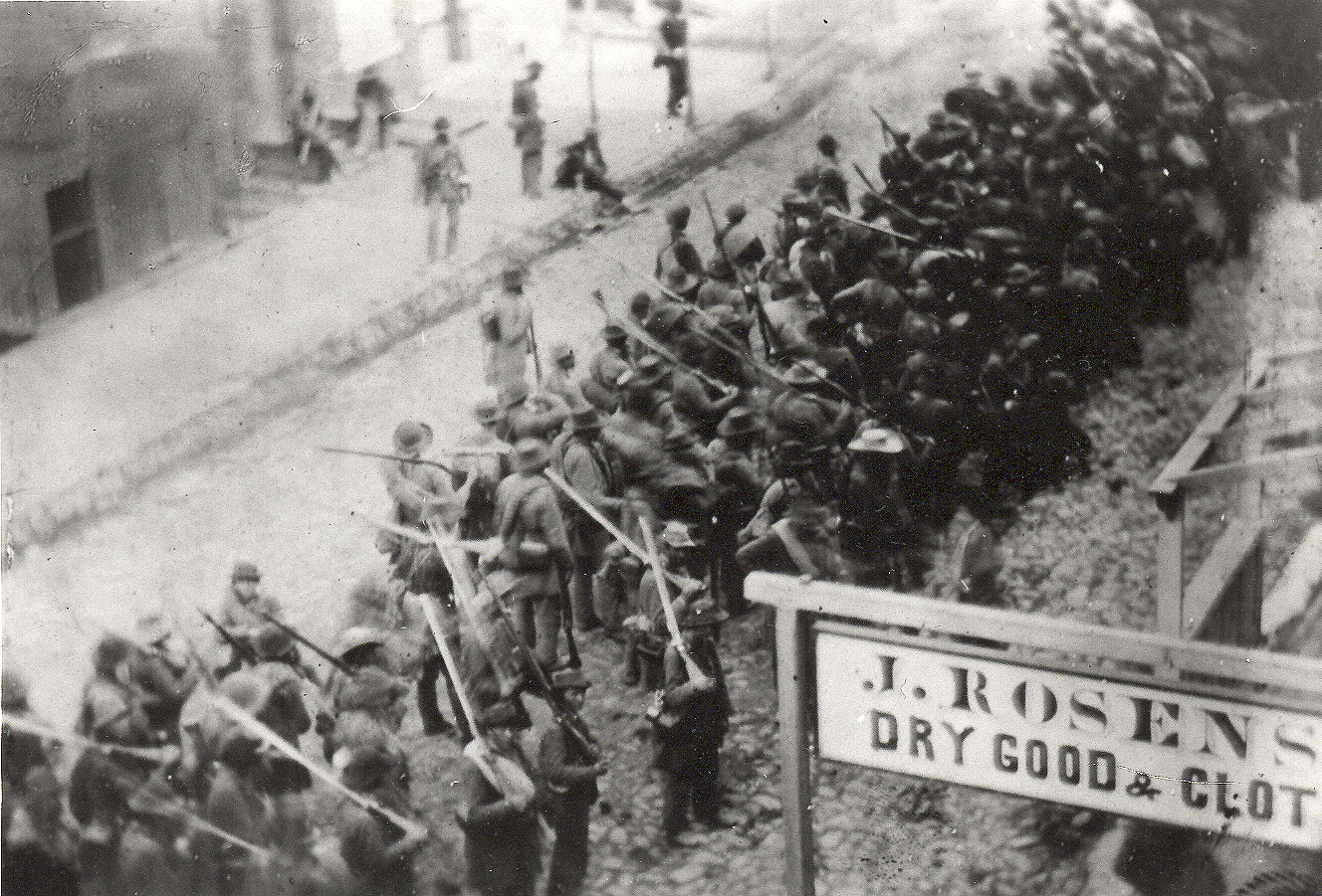 I have not yet found any other photos or descriptions of the store so I can’t find the exact location of the sign. It could be anywhere in front of the store on either Patrick or Market street. However, the structure behind the sign at the right edge of the photo provides a clue. The detail shows how the sign was attached to the structure.
 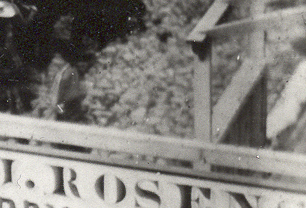 The downward slanting beams behind the sign were probably supports for an awning in front of the store. The structure is probably a porch (or boardwalk) in front of the store. The sign is fastened to the end of the porch and projects out into the street. Historical lore and other clues in the photo place the photo’s location on Patrick Street. From this, the most likely location is just east of 5 East Patrick Street, near the corner of the store. In Google Earth, double-click the “Market and Patrick Street” link to show the area near the Market and Patrick Street corner. The figure
 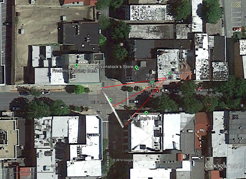 shows other features that I will discuss later. Now check the box next to the Pittar Map item to show a map overlay that is a detail from the Pittar Map drawn later in the century. It shows the map in the area near the corner.
 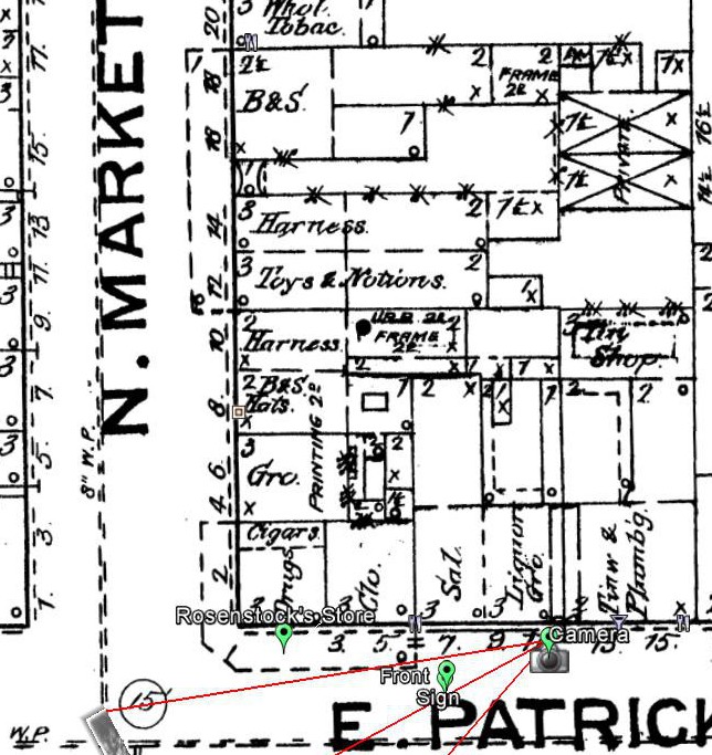 Most relevant to this discussion are Rosenstock’s store and the dotted lines along front of it. There are similar lines in front of the building north of the corner at 12-18 North Market Street. I believe these represent covered porches or boardwalks in front of the two buildings. This is consistent with my interpretation of the structure’s location in the photo.
The Soldiers
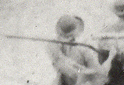
What were the soldiers in the photo doing when the photographer opened the shutter? Take a look at the detail showing who I think is probably the smartest man in the unit. 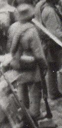 He is in foreground slightly to the left of center. Unlike the other men in the unit, he did not believe in carrying his weapon unless it is absolutely necessary. He is resting with his rifle butt on the ground. This tells me that the unit has halted, which would have been necessary for cameras at that time. Another detail shows three men, two in front and one at the back, staring directly into the camera. Something, probably the photographer yelling or waving, must have attracted their attention. So there we have it, one unknown unit from Robert E. Lee’s force of 45, 000 on the way to bloodiest battle in American history paused briefly on the streets of Frederick to be recorded in this historic photo.
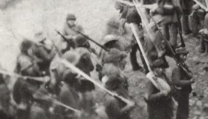
The Camera
From the angle of the shot, the camera must have been located above and to the right rear of the unit. This would place it on the north side of East Patrick Street to the east of Rosenstock’s store. It must have been located in an upper story window or on a roof. In Google Earth, click on the “Photo Reconstruction” link to show the area near the camera. 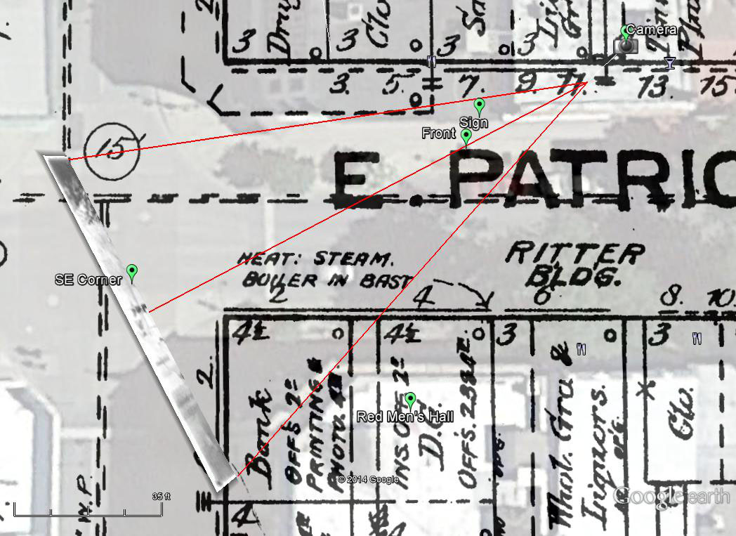 After some trial and error, I chose a camera location so that the alignment of the sign, the troops, and background in the reconstruction matches the photo. I chose a point near 11 East Patrick Street at the second floor level, but the camera could be between 9 and 13 and it could be somewhat higher. So far I have not found pictures or drawings that show the building layout at that location. I can’t be sure whether the Pittar map still applies to the layout in 1862. Having the layout information would help locate the camera more precisely. After setting the camera location, the next step is to set the camera tilt angle, bearing, and view angles. The red lines in the figure show the camera bearing , and view angles projected onto the ground. I can determine the bearing fairly accurately because the gutter in the background must line up with the direction of the street. I adjusted the view angles until the size looked right and adjusted the tilt angle to place the background near the southeast corner of Patrick and Market.
The last step is to tell Google Earth where to place the image in the three-dimensional rendering of the scene. Google Earth renders the image like a billboard at the selected location. I used the special rendering shown in the figure to make some fine adjustments. I set the distance from the camera to the image to position it near the southeast corner of Market and Patrick Streets. As I will mention again later, I interpret the erect figure in the background as a sentry posted near the corner. I made a fine adjustment in the tilt angle to render his image at ground level. The part of the structure within the view angle and in front of the rendered image appears in the photo’s background. It housed the historic Red Men’s Hall. The final rendering, not shown in this figure, was placed closer to the camera at a point near the “Foreground” marker. The two men in the center near the bottom of the photo were standing near that marker. The base of the sign is clipped off in the photo and must have been located closer to the camera.
Perspective View
The next scene is a perspective view placed in a contemporary three-dimensional rendering of the 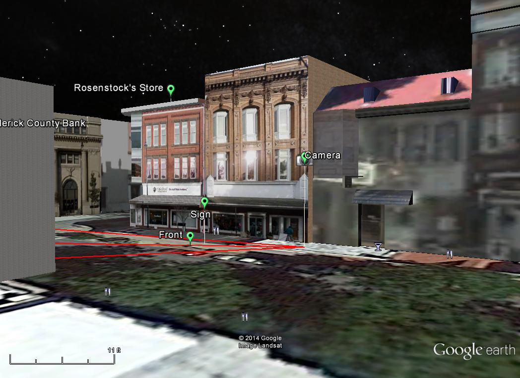 corner. In Google Earth, turn off the map layer by un-checking the box next to “Pittar Map” and checking “3D Buildings” in the “Layers” panel. Then double-click the “Perspective View” link. This picture shows the relative positions of the camera, the sign, and the soldiers in the foreground of the picture. Google Earth constructs this view by combining satellite and Google Street View images. The green patches in the foreground are actually satellite images of the beautiful trees that line the city streets. Frederick for the last 25th years has been designated as a “Tree City U.S.A.”
Through The Photographers Eyes
Double click on the “Photographer’s View” link to show the result. A contemporary three-dimensional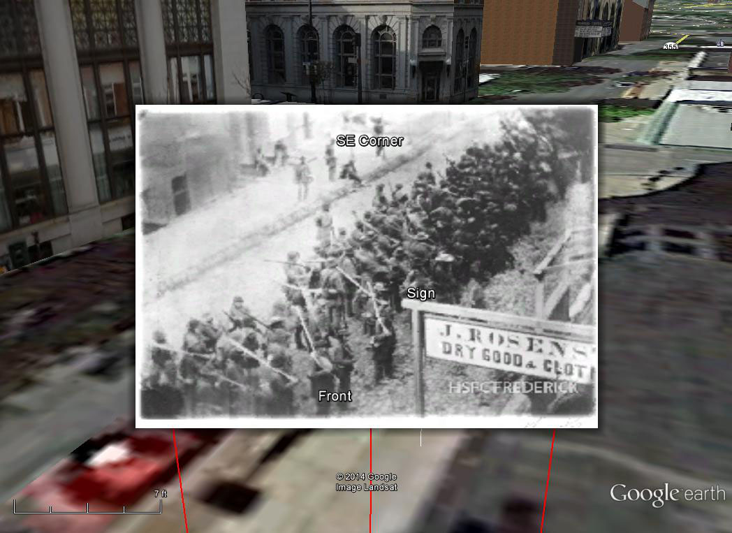 rendering of the south side of Patrick Street is in the background. In the distance, Patrick Street becomes Md. Route 144, Old National Pike, which leads to Antietam. The corner location where Rosenstock’s store stood is in the foreground at the left. In the middle is the reconstruction of the scene viewed through the eyes of the photographer when he captured this unknown unit on its way to join in this historic battle. This completes the reconstruction, but there is much more to be said about the content of the photo.
Details
Go back to the “Historic Photo” link and double-click. This turns on a Google Earth feature that allows you to zoom and pan through the photo and look at details, some of which I will point out here. When you double-click, the zoom and pan control appears in the upper right.
The Background Area
Look at the background area at the top right of the photo. At the right of the photo, the gutter that 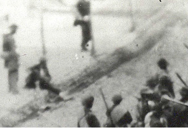 parallels Patrick Street appears to bend off to the left. I interpret that point as the corner of Patrick and Market. I interpret the erect figure standing nearby as a sentinel posted to guard the intersection. To the left of the sentinel, there appears to be a figure seated on the ground. Is he lost or strayed from his unit? Is the figure standing at his left and leaning over him asking questions, yelling at him, or both? We will never know the ending of this little drama accidentally caught in the photographer’s lens. I interpret the structure in the left background to be the building on the southeast corner across from
 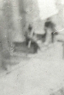 Rosenstock’s store. Unfortunately, so far, I have not found any clear photographs or drawings of the building, so I can not compare the real building to the fuzzy shapes in the photo. There seem to be two figures in the center background, seated on steps or a porch in front of the structure. What was their business in Frederick? Perhaps they were driving supply wagons and had stopped to give way to the more glamorous fighting troops.
The Marchers
This photo, according to an interesting discussion in the Civil War Education Association Facebook page, is the only known photo of Army of Northern Virginia troops in the field as combatants. It shows authentic details about the uniform and equipment of fully armed and equipped Confederate troops. For example, here is a detail showing a soldier wearing what appears to be a blanket roll over his shoulders. Unfortunately, I know very little about that subject, so I will not attempt to go further. One thing that did catch my attention is the hats! I expected to see the broad-brimmed hats on the officers and uniform caps like the one in the third row from the bottom. I did not expect to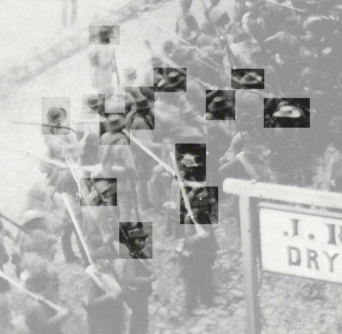 all the other hat styles in the picture. I was looking at a hat store full of styles. Look at the man fourth from the left near the middle. What a hat!
The Two Solders
As I look more and more at the picture, searching for details and clues, I realize it has a profound story to tell. Life for everyone in the picture stood still for the brief seconds it took to capture this image, but for them, everything is about to irreversibly change . It is impossible to understand the raw statistics of the battle they are about to enter: total number of troops, the total number of killed, total wounded. It was an incomprehensible slaughter. This photo allows us to think about individual soldiers. I often think the faces of two men at the bottom just to the left of the sign. The photographer captured them gazing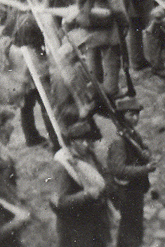 curiously directly at the camera. They look barely old enough to shave. They stand near the rear of the unit, close together but slightly separated from the others. I imagine that they are brothers. Are they recruits who have just joined their unit? I don’t think their officers appreciate their show of curiosity. I know that they, with the other solders in the photo, will soon be engaged in the bloodiest battle in American history. I wonder what happened to them. Because nations always send their youngest men to fight their battles, sadly when they die, they leave this world with wives never embraced, children never born, whole lives never lived. Their backward look at Frederick could be the last time their eyes fell on any civilized place. I hope their fate was different. I hope they survived the war, lived long and prolific lives, and now have hundreds of descendants wondering what their ancestors did in the war.
A Work in Progress
I have tried to present enough details about the reconstruction process to show that my results are reasonable. However, much remains to be done. I am looking for more information about the area around the corner of Market and Patrick Streets. I would love to see photos or drawings that show the nearby buildings as they existed when the photographer took the photo. I am also hoping that there is some clue in the photo that would help narrow down the unit’s identity. Did someone see the photo being taken and write about it? There are theories about who the photographer was, but no one knows can be sure. Are there more photos around somewhere? What photographer is satisfied with just one photo? I hope you enjoy this way of viewing history. I would appreciate any comments that add to the story or correct any details I have wrong.
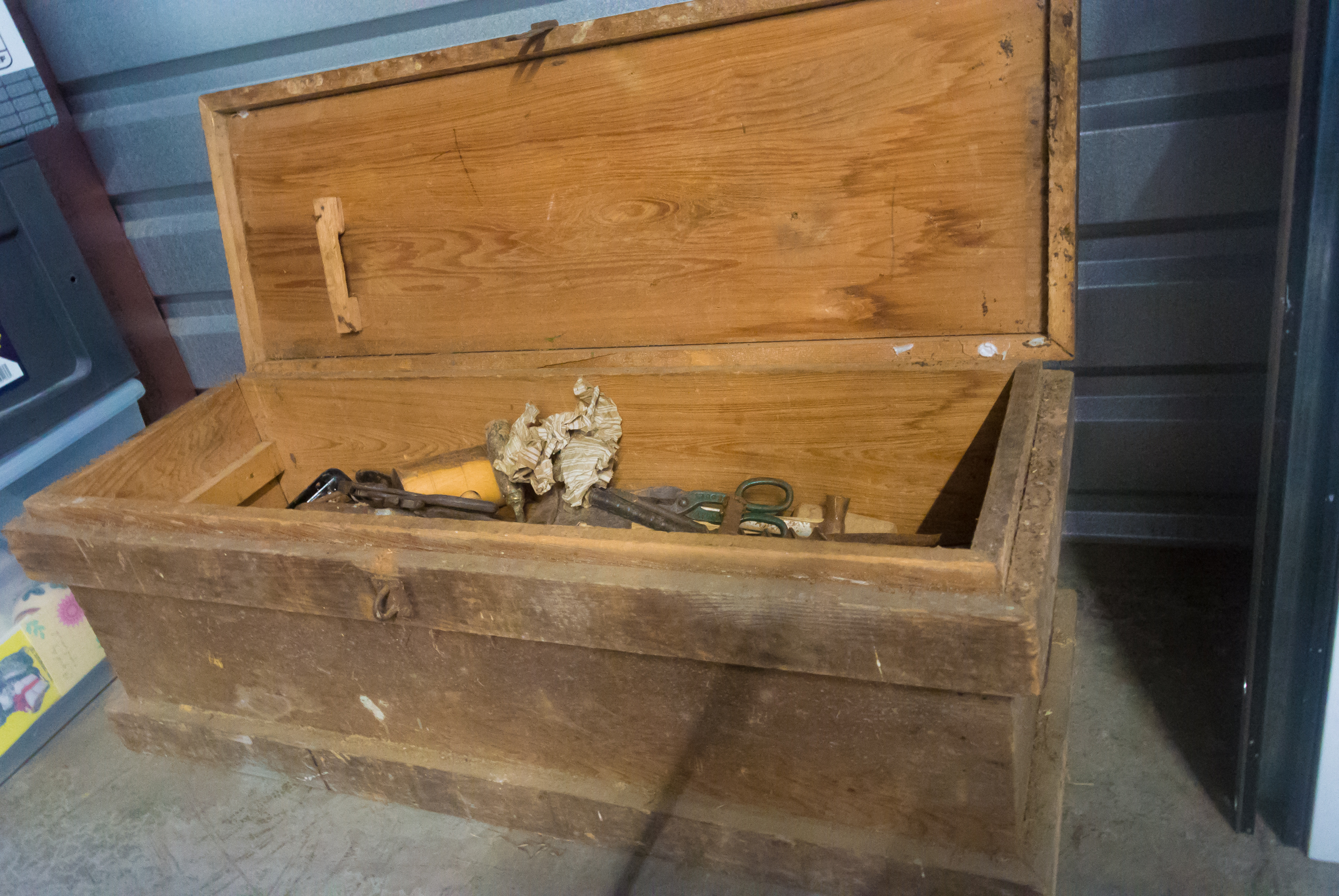 An item in my bucket list is: Clean up your,stuff – don’t leave that to those who come after you! That leads to a story. In 1911 my grandfather married my grandmother and moved to a small farm in Clarksburg, Mass. They kept two or three cows, some chickens, and a vegetable garden. The farm supplemented my grandfather’s income from work in a cotton mill. They lived there until my grandfather died in 1957 leaving me the toolbox and the 125 basic farmhand tools. Following my bucket list, I have decided that it’s time to sell the box on eBay.


